




RTK GPS Survey Equipment SMA26 Rover Base,NOAA Certficated,With Pole And Tripod
Specifications
| Return Shipping Will Be Paid By | Buyer |
| All Returns Accepted | Returns Accepted |
| Item Must Be Returned Within | 14 Days |
| Model Year | 2024 |
| Control Method | App |
| Country/Region Of Manufacture | China |
| Weight | 19.8lb |
| Map Type | Satellite |
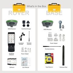
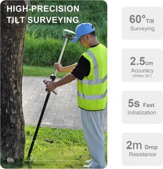
About this item【Rover+Base】The SMA26 RTK GPS SURVEY EQUIPEMNT Surveying Rover+Base+Collector+Surveying Tripod+Surveying Pole represents a comprehensive solution for land surveying needs, encompassing both rover and base station components. It boasts an integrated GNSS receiver, a high-capacity battery, an expansive memory card, and the incorporation of an inertial module automatically compensates for pole tilt, enhancing surveying accuracy within a compact design.【Centimeter-level precision】The SMA26 RTK GPS SURVEY EQUIPEMNT Rover+Base achieves centimeter-level precision within seconds, making it the ideal choice for high-precision surveys. It upholds stable fixed RTK accuracy even in challenging environmental conditions, guaranteeing the fidelity of collected data.With its high-gain antenna,it enhances the efficiency of GNSS satellite signal tracking by up to 50%,ensuring accurate positioning across GPS,Glonass,BeiDou,Galileo, and QZSS constellations.【Applications】RTK GPS SURVEY EQUIPEMNT Helps surveyors precisely establish property lines and boundaries; Enable precise layouts and reduce costly errors during construction projects; Provides the precision needed for environmental assessments and management. Supports accurate design, construction, and maintenance of critical infrastructure. Use WEBUI to set base and rover Please note that: When you receive the new SMA26 RTK GPS device. Long press the power button to turn it on. If the light does not respond, or the light flickers for a while and then goes out. It means that the device is out of power. Please connect the adapter to charge it.Technology in Surveying: Real-Time Kinematic (RTK) GPSThe use of RTK survey GPS equipment represents the leading edge of innovation in the surveying industry. This device makes use of a real-time kinematic (RTK) GPS, which enables it to pinpoint measurement and reference locations in a timely and accurate manner. RTK GPS survey equipment, such as SMAJAYU, does not need processing after the survey has been finished. It allows for instant response to be provided in the field, giving data on accuracy and quality testing without the need to analyze the survey or return to the area for a do-over. This kind of surveying is advantageous for surveyors since it may be used for both level 3 and level 4 surveys at the same time.How does RTK survey GPS work?Real-time surveys conduct using RTK GPS survey equipment with either a Full frequency, but the BDS(BDS B1l/B2l/B3l/B1C/B2a/B2b); GPS(L1C/A/L2P(Y)/L2C/L5); GLONASS(G1/G2/G3); Galileo(E1/E5a/E5b/E6*); QZSS(L1,L2,L5)carrier phase is always employed to bring the survey to its successful conclusion. Due to the frequency capabilities, this indicates that RTK surveys can only be undertaken within a radius of around 5 kilometers (km) from the base.On the other hand, there are occasions when the whole range is employed for the survey, which necessitates shorter distances in order to keep the accuracy level at 1 centimeter. Utilizing a GPS system is both time and labor-saving, but there is uncertain that the outcomes will match your expectations.Why need point Calibration?In order to make the coordinate system in the area consistent with the coordinate system of the external control point, or to unify the two coordinate systems in the area, point calibration is required.How to perform point Calibration?To perform point calibration, you need the coordinates of points in the target system and the current system. The coordinates in the target system can be those of known control points or imported coordinates in the target system. The coordinates in the current system can be directly obtained through RTK surveying.It is generally recommended to select at least 3 points and obtain the coordinates of these points in the target system and the current system for calibration. When doing a survey using RTK GPS technology, a surveyor is limited in what they can accomplish according to the number and location of satellites that are accessible on that particular day. The need to rearrange your calendar to accommodate the satellites may seem to be an additional strain, yet, doing so will really result in an increase in both your productivity and effectiveness.
Related Items